|
A History of the Incorporated
Village
of
Plandome Heights
Researched and written by
ARLENE HINKEMEYER VILLAGE HISTORIAN 1978–1996
Updated by ELEANOR M. IMPERATO
VILLAGE HISTORIAN
Artwork by JOHN S. ALLEN
Photograph
courtesy of the Manhasset Public Library
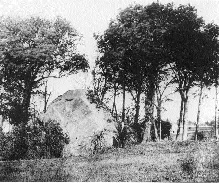
Big Rock
Mr. Tom Hemphill of 89 Shore Road remembers. . .
as a young boy summering in
their house on Shore Road during the 1920s and after. There were only
about two other children then in the neighborhood. They sailed and swam;
he and Esther Morse had bike races through the bulrushes between Shore
Road and the Bay; they climbed on “Big Rock” which was a large glacial
deposit up on the hill above what was then the end of Shore Road.
A Brief Summary and Dateline of Manhasset
History
To start at the beginning and
to put the history of Plandome Heights in perspective:
Perhaps about 20,000 years ago
during the Ice Age. . . the beautiful hilly and stony terrain of
Manhasset and Plandome Heights was formed by the receding mass of glacial
ice.
By about 5000 B.C. there may
have been early Indians living on Long Island.
By 1500 we know from remains
uncovered in the location of the Manhasset Bay Yacht Club, that the
Matinecock Indians peopled the bay area, which they called Sint Sink (
possibly meaning “stone upon stone”). The Matinecock (which may mean
“hilly land”) were one of 12 Long Island Indian tribes.
In 1614 Adrian Block,
following up on Henry Hudson’s voyage to the New World in 1609, was sent
by the Dutch West India Company to explore the area for possible fur
trading sites. Block’s ship probably did sail into Schout’s (the Dutch
name for it) Bay, because a rough map of Long Island was drawn, but the
Dutch never settled the area.
In 1640 the first settlers
arrived. Captain Daniel Howe brought some emigrants from Lynn, Massachusetts
in a small ship and landed near the southern end of the bay in what is
now Manhasset. The settlers said they had a land grant from the British
Lord Sterling, but the Dutch, who claimed prior possession, imprisoned
them for a time in New Amsterdam (New York City), and then let them go;
whereupon they sailed farther out on Long Island and founded the
settlement of Southampton.
In 1643 Robert Fordham and
John Carmen, two English leaders of a religious sect in Connecticut,
bought a strip of Long Island from the Indians and called it “Hempstead.”
The price was some large and small kettles, some wampum and cloth, a
broadax, knives, gunpowder, lead, and a shirt for the chief. This they
paid for all the land running from the North to the South Shore that now
includes Hempstead and North Hempstead.
In 1644 Fordham and Carmen
confirmed their purchase with the Dutch governor William Kieft (who by
this time had decided to encourage British settlement as a hedge against
the Indians) and brought about 30 families from Connecticut to settle.
These settlers lived in Hempstead and used the Port Washington peninsula
as a pasture for their cows, calling it “Cow Neck.” The southern portion
(now Manhasset) was later called “Little Cow Neck,” and the bay “Cow
Bay.”
By about 1658 part of the
now-famous, elusively-situated “cow fence” had been built across the
peninsula. Each settler was allowed to pasture a number of cattle in
proportion to the number of post-and-rail fence “pannels” he had built.
According to records, there were at this time 60 participants in the
common pasturelands project, 526 “panels,” and over 300 beef and dairy
cows roaming the hilly ground. Was Plandome Heights part of the
enclosure? Probably not, since most historians place the fence at a line
running southeast from Leeds Pond, although it could also have been as
far south as what is now Northern Boulevard.
In 1664 the British captured
New Amsterdam from the Dutch. King Charles II granted Long Island to his
brother James, the Duke of York.
In 1674 the former common
pasture in Cow Neck was divided among the settlers, also according to the
number of fence “panels” each had built, except that 200 acres were given
to Captain Matthias Nicoll to defend their common rights. Nicoll was
speaker of the first colonial assembly and secretary of the colony. He
had already bought much of the present-day Plandome area in 1670 and at
his death in 1690 owned 600 acres in the area. He built a home on the
land and it may have been during his ownership that the area acquired the
name “Plandome”, probably from the Latin words meaning “plain home.” It
was probably in 1693 that Joseph Latham built the Plandome grist mill at
Leeds Pond on Nicoll’s property. By 1718 Latham was able to buy Nicoll’s
land, and the mill was known as Latham’s mill.
In 1675 Richard Cornwell
obtained a grant of land in Cow Neck (in present-day Sands Point) and
became its first settler. However, Fordham’s group which lived in
Hempstead and used Cow Neck for pasturage objected to his being there.
One night they tried to demolish his home. Cornwell brought them to
trial, where they were fined and his land grant was upheld.
In 1680 was the date chosen
for Manhasset’s founding, based upon the belief that this was the year
the Willets Court area and north Plandome were first settled.
In 1683 the New York State
counties were formed. Hempstead (including North Hempstead) was included
in Queens County.
In 1720 the Society of Friends
(Quakers) opened the first school and meeting house in the area, on what
is now Northern Boulevard. It was rebuilt in 1812, after being burned by
the Hessians.
In 1775 North Hempstead
(mainly on the Whig or the Patriot side in the Revolutionary War) seceded
from Hempstead Town (mainly Loyalist or Tory) when the latter passed a
resolution supporting George III. After the war, the New York state
legislature officially recorded the secession and in 1784 the first North
Hempstead town meeting was held.
In 1801 North Hempstead
Turnpike (now Northern Boulevard and formerly an old Indian trail) was
opened as a toll road. Plandome Road was a country lane. Most of the
shops in Manhasset were clustered in the valley at the head of the Bay.
The main street was called Valley Road.
In 1802 Christ Episcopal
Church was founded and rebuilt in 1913 after being struck by lightning.
In 1815 the Dutch Reformed Church was built, and then rebuilt in 1898
after a fire. St. Mary’s Roman Catholic Church was dedicated in 1857 on
Plandome Road. The present St. Mary’s on Northern Boulevard was built in
1917.
In 1826 the one-room Manhasset
Valley common school was built and used until 1868.
In 1840 the name “Manhasset”
was adopted, although no one knows for sure why. It may have come from
the name of the “Manhansett” Indians (meaning “island neighborhood”) who
lived in the neighborhood of Shelter Island. In 1857 the community of Cow
Bay also changed its name to Port Washington.
In 1846 the first local
newspaper was published, The North Hempstead Gazette.
In 1868 the 5-room Plandome Road
wooden school was built. It was later torn down in 1914 and a larger red
brick school was built on the same site in 1915. This was torn down in
1972 and replaced by the Manhasset Village Green.
In 1898 the Long Island Rail
Road reached Manhasset and Port Washington. The building of the railroad
brought a boom in the growth of Manhasset.
In 1899 Nassau County was
created as a separate county out of Queens.
After 1900 several shops
started opening up on Plandome Road, which would replace Valley Road as
the main street.
In 1907 Town Hall opened on
Plandome Road and Manhasset became the permanent seat of North Hempstead
Town’s government.
In 1911 Plandome became an
incorporated village.
In 1927 the Manhasset Mail was
first published.
In 1928 Munsey Park began to
be developed by the Metropolitan Museum of Art; many of its streets were
named after American artists.
In 1929 Plandome Heights
became an incorporated village.
During the 1930s much of
Manhasset was built by housing developers: Munsey Park, North Strathmore,
South Strathmore, Shorehaven, Norgate, Strathmore Vanderbilt, Chester
Hill (the Bournedale area), and some of Flower Hill.
In 1934 the Manhasset Press
was first published.
In 1935 Manhasset High School
opened, built on the Henry F. Thompson estate as a Public Works Project
during the Depression.
In 1936 Nassau became the
first county in New York State to adopt a county charter. It went into
effect in 1938.
In 1939 Munsey Park Elementary
School was built.
In 1941 the development of the
“Miracle Mile” on Northern Boulevard began and was continued after World
War II. During the 1940s Strathmore Village and Manhasset Cove were built
by housing developers.
In 1946 Manhasset’s first
public library opened in a rented storefront on Plandome Road.
In 1952 the present Manhasset
Public Library opened on Onderdonk Avenue. Also in 1946, the Church of
Our Savior Lutheran was built on Northern Boulevard.
In 1949 the Congregational Church
was built on Northern Boulevard, and the present Post Office on Maple
Place was built.
In 1951 much of Flower Hill
was built.
In 1953 the construction of
North Shore Hospital began.
In 1959 Temple Judea was built
on Searington Road. In 1968 Shelter Rock Elementary School was built.
In 1979 Plandome Heights
celebrated its 50th Anniversary of incorporation.
In 1980 Manhasset celebrated
its 300th birthday. A history of the Manhasset area, Manhasset—The First
300 Years, was published to commemorate the event.
In 1984 a 19.7 million dollar
bond referendum was passed to expand and renovate the three public school
buildings.
In 1985 hurricane Gloria hit
Manhasset. There were widespread power outages and fallen trees. Plandome
Heights residents of lower Shore Road, The Beachway, and the Tideway were
evacuated because of flooding. Also in 1985, the Town of North Hempstead
had a Bicentennial Celebration featuring a carnival, a parade, and a
fireworks display.
In 1989 a gazebo was built on
the site of Manhasset Green which was subsequently renamed Mary Jane
Davies Park in honor of this long time community activist.
In 1995 the Manhasset Public
Library celebrated its 50th Anniversary.
In 1996 a 21.5 million dollar
bond referendum was passed to improve the three public school building
systems, to increase instructional space at the Munsey Park School and at
the Shelter Rock School, to provide technology for instructional
improvement, and to provide the means for compliance with the Americans
with Disabilities Act.
In 1997 Leeds Pond was dredged
and cleaned up of accumulated silt due to rainwater and storm water
runoff.
In 1998 the historic 17th
Century Nicoll House in Plandome Manor was demolished.
In 1999 Plandome Heights
celebrated its 70th Anniversary of incorporation.
In 2000 major renovations to
the Manhasset Station of the Long Island Railroad were completed two
years after the 100th Anniversary of its first operation to Manhasset.
In 2001 the Plandome Heights
Women’s Club celebrated its 25th Anniversary.
Early Plandome Heights 1680-1920
The history of the entire
Manhasset area in the 1600s, 1700s, and early 1800s is sketchy. There are
few major primary sources available from the period other than the
8-volume Records of the Towns of North and South Hempstead. Researching
early land ownership is greatly complicated by the fact that the early
land grants and deeds describe property boundaries by the cow fence, by
some landmark such as a brook, tree, or rock, or by the edge of another
man’s property, and the location of these markers is not now known.
Research into the period is also greatly confounded by the fact that
recent publications on Manhasset history, few as they are, are full of
conflicting facts and dates.
Nevertheless, the area we now
call Plandome Heights seems to have a rather surprisingly distinguished,
though previously unrecognized, history and may also have been the site
of one of the earliest homes on Cow Neck.
The Cow Neck Historical
Society’s Sketchbook of Historic Homes (1963) lists one historic home in
Plandome Heights that was once owned by Mrs. Howard Morse of 69 Shore
Road. Unfortunately the home was burned in a fire in 1965, but the
Sketchbook describes it as being built about 1710 on land granted to one
Nathaniel Pearsall as early as 1686. The earliest known owner, then, of
the land that became Plandome Heights was Nathaniel Pearsall.
The
Pearsall Family
The Pearsall family was one of
the most prominent early families in the town. Henry Pearsall, the father
of Nathaniel, had come to Long Island from the colony of Virginia where
his father Thomas Pearsall was a leader of the tobacco traders in the
Chesapeake Bay area. Henry Pearsall became one of the 50 original
proprietors of the Town of Hempstead. He was one of the group mentioned
earlier, headed by Fordham and Carmen, which had bought a strip of Long
Island from the Indians in 1643, had confirmed it with the Dutch governor
Kieft in 1644, had settled in Hempstead, and used Cow Neck for pasturage.
Henry Pearsall himself is recorded in the town records of 1657 or 1658 as
having 12 “gattes” of the cow fence and 12 head of cattle on Cow Neck.
The 3-volume History and Genealogy of the Pearsall Family in England and
America states that Henry Pearsall was the sixth largest landholder in
the town.
If the Sketchbook is accurate,
Nathaniel Pearsall (1649–1703), the eldest of Henry’s four sons, was
granted a piece of land in present-day Plandome Heights by the town
proprietors in 1686, under the British governor Dongan’s patent. Nathaniel
must have been a capable man because from 1672 (when only 23 years old)
to 1682 he was voted the clerk of the Town of Hempstead, recording all
the town business, and in later years held other important positions as
well, such as town assessor and town supervisor. For more than 30 years
he was one of Hempstead’s foremost leaders and represented the town in
controversies with the governor and with neighboring towns.
As the eldest son, Nathaniel
was given the responsibility of dividing his family’s considerable
property among himself and his brothers Daniel, George, and Thomas.
Although it is not known for certain who the next owner of the Plandome
Heights area was, it seems highly likely that it passed down through his
brother Thomas’s family. In 1692 it is recorded that as part of the
division of the family’s lands, Nathaniel Pearsall gave to his brother
Thomas Pearsall “one third part of my wright on Cow Neck.”
If Thomas Pearsall was the
next owner of the Plandome Heights land, it is possible that he was the
one who built the farmhouse on the land around 1710. It must have been a
beautiful spot: a lush green level area right on Manhasset Bay with a
bubbling fresh-water spring nearby, perfect for watering cattle. The
house could be reached either by boat or by horseback. A steep sandy
bluff rose up from the Bay to the east of the house, making it a
sheltered and secluded spot.
The home had massive open
beams that ran the length of the living and dining rooms and were made of
hand-hewn red oak. The oak, also used on the exterior, came from the
sturdy red oaks which lined Long Island’s harbors. When Howard and Reba
Morse moved into the home in 1923 it still had the original handmade
nails and many of the original panes of hand-blown glass.
We do not know how much of the
Plandome Heights lands the Pearsall family might have owned. All of the
village today only totals about 220 acres. We do know that farms in the
North Hempstead area generally varied in size from 70 to 300 acres. We
also know that during the seventeenth and eighteenth centuries, farming
in the area was of the subsistence type. Settlers provided practically
all of their own needs for food, shelter, and clothing.
By the beginning of the nineteenth
century, however, farmers began to produce some cash crops— such as
apples, potatoes, grains, and milk—for consumption by the local markets
and by New York City. From what we know of the Plandome Heights terrain –
that it included level stretches and sloping areas and had fresh water
springs and streams – we can induce that part of the area may have been
more conducive to farming, part to grazing cattle, and part (the sandy
bluff) to neither use.
Sometime around 1800 a barn
was built on the property and probably functioned as the barn for the
Morse farmhouse. It is now the oldest surviving structure in Plandome
Heights and is located at 62 Shore Road. More will be said about the
history of this house later.
In reading through the town
records for the early 1800s we learn a few more facts about the area. In
1819 the Town of North Hempstead (it had seceded from Hempstead in 1775)
laid out nine school districts. What is now Plandome Heights was included
in District No. 6 which was called the “Head of Cow Neck.” In 1831, when
the town changed its road districts from names (our area was called the
“head of Cow Neck, western district”) to numbers, what is now Plandome
Heights was included in district No. 7. The only real significance of
this is that in 1843 it is recorded that Charles W. Pearsall was elected
the overseer of highways for district No. 7, which proves that the
Pearsall family still owned land in our area. This Charles Willets
Pearsall (1802-1861), by the way, whose mother was a Willets, was also
the great, great grandson of the previously mentioned Thomas Pearsall,
the brother of Nathaniel.
 This
brings us up to the 1850s after which tracing land ownership is much
easier, mainly because of the presence of actual maps. There are maps of
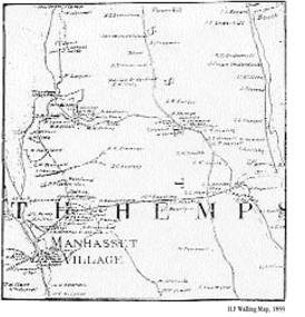
Long Island which show the Plandome Heights area in 1797 and in 1852, but
the first map available which shows actual land ownership is the Walling
map of 1859. This
brings us up to the 1850s after which tracing land ownership is much
easier, mainly because of the presence of actual maps. There are maps of
Long Island which show the Plandome Heights area in 1797 and in 1852, but
the first map available which shows actual land ownership is the Walling
map of 1859.
Here we see that the Willets
family owned the farmlands directly to the north of what is now Plandome
Heights in the present vicinity of Willets Lane. Isaac Sherwood owned the
farm directly south, his drive becoming what is now Colonial Parkway.
Colonel Andrew A. Bremner owned the farm and home directly south, to the
east, mainly in Flower Hill, although his property also included what is
now the Bournedale area.
This leaves Charles W.
Pearsall and William Haviland as the two main property owners of Plandome
Heights in the mid 1800s. It is not known exactly when Haviland first
acquired property in the area. It is known that he was elected highway
overseer for district No. 7 for the years 1859, 1860, and 1861 and is
listed on the 1859 Walling map, so he obviously owned the property before
1859. He may have inherited it when his father Roe Haviland died in 1844.
Charles Willets Pearsall, we
know, owned the Plandome Heights lands until his death on May 18, 1861 at
which time the property passed to his brother Thomas W. Pearsall
(1795-1866). Then it is recorded that a month later on June 26, 1861
Thomas W. Pearsall and his wife Mary Leggett (they were married at the
Dutch Reformed Church in Manhasset but lived on a farm in Westchester
County) deeded two parcels of land to William Haviland of Manhasset. One
was a 29-acre parcel north of Sherwood’s property and one was a 15 ½-acre
parcel across Plandome Road where Plandome Court is now. Both parcels
were probably contiguous to the land Haviland already owned in the
Plandome Heights area.
This seems to mark the end of
the Pearsall family’s ownership in Plandome Heights because a Walling map
from 1863 shows only William Haviland as a landowner. So for the next few
decades the history of Plandome Heights becomes the story of the Haviland
family and its descendant Bloodgood Cutter.
 The
Haviland Family The
Haviland Family
The Haviland family, like the
Pearsall family, was an old landed Long Island family with many branches.
It could trace its American roots back to 1653. The main branch of the
Haviland family in North Hempstead lived in what is now Little Neck.
William Haviland inherited a
great deal of land in North Hempstead when his father Roe Haviland died
in 1844. He then engaged in a considerable amount of buying and selling
of property. It could be noted here that most of the early landed
families did. They may have owned certain lands that stayed in their
families over a long period, but other parcels were continuously being
bought and sold, which makes research very difficult.
In any case, during the 1840s,
1850s, and 1860s William Haviland and his relatives sold one parcel after
another, perhaps because of declining family fortunes. During the time
Haviland owned the Plandome Heights properties he and his wife Grace may
have lived in the farmhouse on the Bay. As seen in the 1859 and 1863
Walling maps, the approach to the house and barn was a curving road along
the approximate route of the present Bay Driveway and Shore Road.
While William Haviland was
selling numerous parcels, Bloodgood Haviland Cutter was buying. However,
Haviland also willed some property to Cutter, including the Plandome
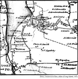
Heights lands pictured in this Beers map of 1873. It is not known exactly
how Haviland was related to Cutter, but they must have had a fairly close
relationship for Haviland to have included Cutter in his will. In age, if
not in fact, Haviland was probably something like an uncle to Bloodgood.
 Bloodgood
Haviland Cutter Bloodgood
Haviland Cutter
The man with the awesome name
of Bloodgood Cutter was certainly one of the most colorful figures in
Plandome Heights’ past. He was born on August 5, 1817 in Little Neck in his
grandfather Roe Haviland’s house (which later became the “Homestead Inn”
on Northern Boulevard) and lived there until his marriage. He had only a
limited education, mainly from the Bible, at a small school in Lakeville,
for his grandfather who raised him thought farm work was more important.
His parentage is unclear, for his father is never mentioned; his mother’s
maiden name is given as Mary Bloodgood of Flushing. One source reports
that his parents died when he was young.
However unclear his roots, he
managed to marry well. On November 12, 1840 at the age of 23 he eloped
with Miss Emeline Allen, then 16 years old, by putting the proverbial
ladder under her window. Her father was opposed to the match. The Allen
family owned a great deal of property and a mill in Great Neck. Cutter
later acquired the mill, after which Cutter Mill Road is named.
Cutter’s grandfather Roe
Haviland died in 1844, leaving him the Prospect Hill farm in Great Neck
where he and his wife went to live. During the next few decades Cutter
bought much of the Haviland property at auction and many other parcels
besides. He acquired his birthplace and several Manhasset properties
fronting on Plandome Road. The Plandome Heights properties were willed to
him by William Haviland. Then, fulfilling a longtime desire, he booked
passage on the steamer Quaker City for a trip to the Holy Land from June
to October of 1867.
Bloodgood by this time was 50
years old and well established as a “character.” He had an Irish face, it
is said, wore old-fashioned clothes, spoke with a country accent, and was
always writing poetry (“doggerel” they called it)! He wrote Bloodgood
Haviland Cutter poems for every conceivable occasion: for the Flushing
County Fair in 1861, for the laying of the cornerstone of the Flushing
Town Hall, for the Quaker barn dance, for the burning of his mill, for
the death of William Cullen Bryant, and for many other events.
He wrote poems to numerous
ladies on board the ship (his wife did not accompany him on the trip) and
a long 130-page poem detailing the entire journey. It so happened that
Mark Twain was also aboard the ship and Bloodgood Cutter, with his
eccentric ways, became the character the “Poet Lariat” in Twain’s book
Innocents Abroad.
This is how Twain described
Cutter in his notes for the book:
He is 50 years old, and small
for his age. He dresses in homespun, and is a simple-minded, honest,
old-fashioned farmer with a strange proclivity for writing rhymes. He
writes them on all possible subjects and gets them printed on slips of
paper with his portrait at the head. These he will give to any man that
comes along, whether he has anything against him or not.
And this is the character, the
“Poet Lariat,” that Mark Twain created, as quoted from his book Innocents
Abroad:
. . .but we have a poet and a
good-natured enterprising idiot on board and they do distress the
company. The one gives copies of his verses to consuls, commanders,
hotel-keepers, Arabs, Dutch, — to anybody, in fact, who will submit to a
grievous infliction most kindly meant. His poetry is all very well on
shipboard, notwithstanding when he wrote an “Ode to the Ocean in a
Storm,” in one-half hour, and an “Apostrophe to the Rooster in the Waist
of the Ship” in the next, the transition was considered to be rather abrupt;
but when he sends an invoice of rhymes to the Governor of Fayaland
another to the commander-in-chief and other dignitaries in Gibraltar,
with the compliments of the Laureate of the Ship, it is not popular with
the passengers.
Twain’s evaluation of Cutter
seems to have been accurate: that his poetry was atrocious, but that he
was a kindly, well-meaning soul. In fact, Cutter was well regarded at
home, with a reputation for great honesty and business acumen. Cutter was
not at all insulted by the passage. In fact, he was delighted, and for
the rest of his life loved to be referred to as the “farmer-poet” and the
“Poet Lariat.”
Cutter was such a colorful
character that he frequently found himself in the news. In 1880 he took a
trip to Ireland, Scotland, England, and France with his wife. On August
9, 1880 on the New York Times obituary page, no less, a short item
appeared stating: “The report that Bloodgood Cutter, the distinguished
Long Island farmer and ‘Poet Lariat’ in Mark Twain’s Innocents Abroad, had
died in London, is untrue. He is in Scotland with his wife.”
Unfortunately, a death was
imminent. On March 24, 1881 his wife Emeline had died. Cutter never
remarried. Once in 1893 it was rumored that he had eloped and remarried,
and a reporter from the Brooklyn Eagle hastened to his home. Cutter
squashed the rumor with the quotable reply that “his only bride was his
muse and that he had no intention of committing bigamy.”
Probably one of Bloodgood’s
proudest moments came in 1886 when his book, entitled The Long Island
Farmer’s Poems was published by N. Tibbals and Sons of New York “for the
author,” meaning it was a vanity press. The book contains 500 pages of
his poetry, including the long poem “The ‘Quaker City’ Excursion” about
his trip to the Holy Land. A small, humorous to the reader, portion of
this poem appears below.
Seven doctors I found on board,
Very clever, and men of wealth;
They gave us pilgrims good advice,
So that we could preserve our health.
Of clergymen there were just three;
On board they used to pray and preach;
Of different creeds they all were,
Yet still they did sour’d doctrine teach.
Lawyers and judges too were there,
Captains, and four colonels too;
Correspondents, writing here and there,
In the saloon our voyage through.
One droll person there was on board,
The passengers called him “Mark Twain;”
He’d talk and write all sort of stuff,
In his queer way, would it explain.
About twenty ladies were on board,
Most of them very pleasant too;
And they were all so well informed,
Could converse on subjects old and new.
And very friendly too they were,
Especially if one was sick;
They would get things for your relief,
Their nursing would restore you quick. . . .
It made me feel, though, very queer,
To see Long Island disappear;
As we steamed on it seemed quite small,
Before night could not see it at all.
At two the dinner gong did sound,
In the saloon we gathered round;
The table was pleasing to my view,
With poultry, meats, and puddings too.
The sea makes keen my appetite,
I eat my food with great delight;
When done I go upon the deck,
To enjoy there the grand prospect.
Some up and down the deck do walk
Some sit in groups, and then do talk;
Some sit and read, others do sleep,
And some stand gazing on the deep.
At six o’clock we have our tea,
Then go on deck to view the sea;
At nine o’clock the gong does ring,
To call us then to pray and sing.
Most of the pilgrims did attend,
Thus pleasantly the evenings spend;
Some did not heed religious ways,
But spent their time in idle plays.
About ten retire to my berth,
To bid adieu to scenes of earth;
And as the ship does plunge and roll,
It rocks to sleep my weary soul.
Mrs. Howard Morse of 69 Shore Road remembers . . .
when she was a young girl, she and her mother once visited Bloodgood
Cutter in the farmhouse that her parents would later buy. She said the
home was full of antique English furniture that Cutter collected. He
talked quite a bit about knowing Mark Twain, she recalled.
Bloodgood Cutter died
peacefully on September 26, 1906 at the age of 89 and was buried at
Zion’s Episcopal Church on Northern Boulevard in Douglaston in the
Haviland family’s plot. Cutter left the estate of about $500,000, much of
which, including the Plandome Heights lands, he willed to the American
Bible Society. A three-day auction was held to dispose of his large
collection of antiques and books. Ten years later $150,000 in cash and
securities were found in a home safe, along with many unpublished poems.
A newspaper account stated about the latter that “the executors were not
worried about treasure seekers molesting them.”
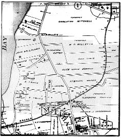 The
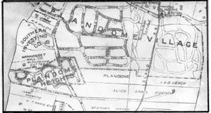
E. Belcher Hyde’s map shows that what the Plandome Heights area looked
like in 1906 at Cutter’s death. The maps from 1886 and 1896 show little
property change in the immediate area from the previously shown 1873 map,
except that at the death of Charles H. Smith, a lawyer, the property
which he had bought from Col. Bremner passed to his wife. The
E. Belcher Hyde’s map shows that what the Plandome Heights area looked
like in 1906 at Cutter’s death. The maps from 1886 and 1896 show little
property change in the immediate area from the previously shown 1873 map,
except that at the death of Charles H. Smith, a lawyer, the property
which he had bought from Col. Bremner passed to his wife.
This 1906 map is the first map
which clearly shows property boundaries and the locations of buildings.
In 1906 the Willets estate still lay to the north, and the Sherwood
property to the south. Cutter, as you can see, owned all of what would in
1929 become the Incorporated Village of Plandome Heights. For until
December 1904, he even owned what is listed on the map as the Gallagher
property.
When the Gallagher family
bought the land in January of 1905 (another person owned the property for
a month) it was level with Plandome Road at the top and then dropped into
a steep sandy bluff down to the Bay. For several years the Gallagher
Company sand-mined the area. Small barges on the Bay removed the mined
sand, and as legend goes, carried it to Manhattan to build the sidewalks
of New York.
M. Douglas Neier of Manhasset remembers. . .
how the sand mining was done
on the Plandome Heights sand bank. There was a short railroad track at
the bottom of the sandy hill in our village. The mined sand from the hill
was loaded onto sand cars and an engine pulled them onto a trestle
located where The Beachway is now. Then from the trestle, the sand was
poured down chutes into the scows or small flat-bottomed barges docked
there on the Bay.
The company used Bloodgood
Cutter’s farmhouse on the property as an office. After the sand gave out,
(and before Plandome Road collapsed, which some people had feared)
Gallagher sold the land to the Manhasset Hill Realty Company. It should
be added that most of the Gallagher family’s holdings (there were at
least two generations of Gallagher brothers in the business) were
concentrated in the Port Washington sand pits. By the 1920s they had
formed the Goodwin and Gallagher Sand & Gravel Company.
The 1906 map also shows that
Mrs. Charles H. Smith’s property had been bought by Alice Grace D’Oench
in the early 1900s. She, like Cutter, would figure prominently in
Plandome Heights history, even though the area she owned west of the
railroad tracks would not be annexed to the village until 1949.
Alice
Grade D’Oench
Alice Grace was the oldest of
eleven children born to Lillius and William Russell Grace. William Grace,
born in Ireland, was the famous international merchant and ship-owner,
perhaps best known for the Grace Lines, who controlled most of the trade
between the United States and South America in the last quarter of the
19th century. He was also elected the first Roman Catholic mayor of New
York City in 1880, and was reelected in 1884. In 1897 he and his brother
established the Grace Institute in New York City to educate young women
in the domestic sciences, stenography, and dressmaking. In 1933 William’s
son, Joseph P. Grace, built a branch of this same Grace Institute on
Northern Boulevard a little west of Plandome Road. William Grace owned a
residence in New York City as well as the beautiful home called
“Gracefields,” and property in Great Neck, much of it concentrated around
the present-day Grace Avenue. He died in 1904, but his company W. R.
Grace and Company has been continued and expanded by his descendants.
Alice Grace, his daughter, was
first married to William E. Holloway, and on January 10, 1901, to Albert
F. D’Oench, an architect. D’Oench was appointed superintendent of
buildings in Mayor Grace’s second administration but resigned in 1889 to
continue his independent practice as an architect. Alice and Albert
D’Oench had one child, Russell Grace D’Oench. On Flower Hill they built a
beautiful English-style estate which was famous for its 150-year old
trees and formal gardens. Albert D’Oench died in Manhasset on July 20,
1918 but his wife lived until 1932.
The Long
Island Railroad Reaches Manhasset - 1898
At this point, the importance
of the Long Island Railroad in Plandome Heights’ developments should be
emphasized. The Manhasset area was definitely rural in the 19th century.
Then the railroad was extended to Manhasset and Port Washington in 1898.
Suddenly, wealthy people such as the Paysons, Whitneys, Munsons, and
Masons from New York City had easy access to the beauty of the North Shore,
purchased the farmlands, and built magnificent estates. During the first
quarter of the 20th century, parts of Manhasset and Plandome Heights,
too, became exclusive areas.
In the Plandome Heights
locale, the D’Oench estate lay to the east. Plandome, which was
incorporated in 1911 to preserve its home rule, lay to the north. In 1909
Benjamin N. Duke of the Duke tobacco family purchased Cutter’s property
from the American Bible Society to whom Cutter had willed it. Duke bought
the heights – the high level lands to the east and west of Plandome Road
– in the name of the “Plandome Heights” Company, and Plandome Heights as
a distinct area was born.
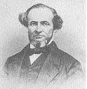
Benjamin
N. Duke
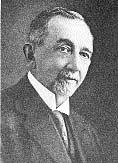 Benjamin
Newton Duke (1855-1929) and his younger brother James Buchanan Duke
(1856-1925) were born on a tobacco farm near Durham, North Carolina, to
Washington and Artelia Duke. Their father built a factory in Durham in
1874, which became the basis of the family fortune. James later started
the manufacturing of cigarettes by machine, which developed the Duke
fortunes into one of the largest in the country. By 1890 the Duke
brothers had formed the giant American Tobacco Company with James as
president and Benjamin as one of the directors. James Duke’s strength was
in business organization, while Benjamin Duke was more interested in
education and philanthropy. Due to Benjamin’s influence, the Duke family
was estimated to have eventually contributed from $90 –$100 million to
hundreds of institutions including colleges, hospitals, orphanages,
churches, and various charities. Benjamin N. Duke Benjamin
Newton Duke (1855-1929) and his younger brother James Buchanan Duke
(1856-1925) were born on a tobacco farm near Durham, North Carolina, to
Washington and Artelia Duke. Their father built a factory in Durham in
1874, which became the basis of the family fortune. James later started
the manufacturing of cigarettes by machine, which developed the Duke
fortunes into one of the largest in the country. By 1890 the Duke
brothers had formed the giant American Tobacco Company with James as
president and Benjamin as one of the directors. James Duke’s strength was
in business organization, while Benjamin Duke was more interested in
education and philanthropy. Due to Benjamin’s influence, the Duke family
was estimated to have eventually contributed from $90 –$100 million to
hundreds of institutions including colleges, hospitals, orphanages,
churches, and various charities. Benjamin N. Duke
In 1911, after five years of
litigation, the Supreme Court ruled that the American Tobacco Company
should be dissolved as a combination in restraint of trade. Benjamin Duke
had already begun to divert his capital to other enterprises such as
cotton mills, banks, railroads, and hydroelectric power plants in the
South, and to real estate in New York and New Jersey. After 1911 he
devoted himself exclusively to these enterprises and to his many
philanthropic endeavors.
The Plandome Heights Company
was one of Benjamin Duke’s real estate ventures. It was rumored within
the village that Duke became disenchanted with the community at Tuxedo
Park, New York, so he decided to create his own social environment in
Plandome Heights.
 1910
the Great Neck civil engineering firm of J. W. Jacobus surveyed and
plotted the area. Plandome Court was laid out and called the first
section of Plandome Heights. Summit Driveway, Summit Place, Grandview
Circle, Bay Driveway, and Bayview Circle were laid out and called the
second section of Plandome Heights. The names of these streets, one can
reasonably surmise, came from their location. Summit Place and Driveway
were on the summit of the hill; Grandview Circle was a circular drive
with a “grand view” of the Bay; Bay Driveway was the drive running down
to the Bay; and Bayview Circle was a circular road giving a close view of
the Bay. 1910
the Great Neck civil engineering firm of J. W. Jacobus surveyed and
plotted the area. Plandome Court was laid out and called the first
section of Plandome Heights. Summit Driveway, Summit Place, Grandview
Circle, Bay Driveway, and Bayview Circle were laid out and called the
second section of Plandome Heights. The names of these streets, one can
reasonably surmise, came from their location. Summit Place and Driveway
were on the summit of the hill; Grandview Circle was a circular drive
with a “grand view” of the Bay; Bay Driveway was the drive running down
to the Bay; and Bayview Circle was a circular road giving a close view of
the Bay.
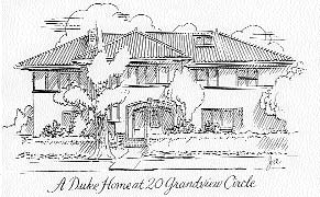
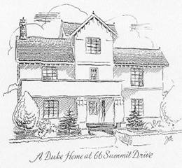 Over
the next few years several Spanish-style homes, which was a popular style
in the early 1900s, were built with white stucco exteriors and red-tiled
roofs. A walk through Plandome Heights reveals which of the homes, which
villagers now call the “tobacco houses,” must have been part of the
originally planned Duke community. On the east side of Plandome Road
there are four such homes: one supposedly set aside for the Dukes at 64
Plandome Court; one at 164 Plandome Court; and two side-by-side at 808
and 832 Plandome Road. On the west side of Plandome Road these Spanish-style
homes are located at 665 Plandome Road, at 66 and 90 Summit Drive, and at
5, 20 and 33 Grandview Circle. One Duke home, at the entrance to Summit
Drive, has since been torn down. Over
the next few years several Spanish-style homes, which was a popular style
in the early 1900s, were built with white stucco exteriors and red-tiled
roofs. A walk through Plandome Heights reveals which of the homes, which
villagers now call the “tobacco houses,” must have been part of the
originally planned Duke community. On the east side of Plandome Road
there are four such homes: one supposedly set aside for the Dukes at 64
Plandome Court; one at 164 Plandome Court; and two side-by-side at 808
and 832 Plandome Road. On the west side of Plandome Road these Spanish-style
homes are located at 665 Plandome Road, at 66 and 90 Summit Drive, and at
5, 20 and 33 Grandview Circle. One Duke home, at the entrance to Summit
Drive, has since been torn down.
Benjamin Duke never actually
lived in Plandome Heights. His home for a few decades, until his death,
was at East 89th Street and Fifth Avenue in Manhattan. Perhaps he had
developed the community purely as a real estate investment. Or perhaps he
had originally planned to summer here with his friends and then changed
his mind. In any case, the Plandome Heights Company retained its
investment in the area through 1920, although Duke did not remain its
president during that entire period.
Benjamin Duke died in January
of 1929, the year that the community he planned became an incorporated
village. He was survived by his wife, the former Sarah Pearson Angier of
Durham, North Carolina; his daughter Mary Duke Biddle; and four
grandchildren. One of his two sons died in childhood; the other, Angier
B. Duke, died in 1923. Doris Duke, the well-known tobacco heiress, was
his niece, being the only child of his brother James B. Duke.
 The
Belcher-Hyde map below shows what the Plandome Heights community looked
like in 1914. You will notice, however, that the scale is inaccurate: the
Plandome Court area is too large, and the undeveloped section is too
small. The
Belcher-Hyde map below shows what the Plandome Heights community looked
like in 1914. You will notice, however, that the scale is inaccurate: the
Plandome Court area is too large, and the undeveloped section is too
small.
The Spanish-style home at 64
Plandome Court was owned by George Klackner. The other “tobacco houses”
are shown to be owned by Clifford Barber, John J. Hoff, Mrs. Nugent,
Helen Weinberg, A.C. Gwymere, F.C. Gilsey, and the Navahoe Realty
Company.
You will also notice that
there are two connecting lanes on the map between Summit Driveway and Bay
Driveway. These may have originally been planned as beach easements so
summer residents could reach the popular beach at the foot of Bay
Driveway. Even though these streets were never built, they still appear
on Nassau County maps today.
Another Belcher-Hyde map from
1914 shows the entire Manhasset area. The scale of Plandome Court in
relation to the undeveloped area is still inaccurate.
Here it can be seen that part
of Cutter’s former holdings were still listed in his name and part of his
former property was owned by Manhasset Hill Realty Company, which had
bought it from the Gallaghers.
The Manhasset Hill Realty
Company was owned by Henry F. Thompson who acquired a considerable amount
of property in Manhasset. Eventually his estate included the large parcel
south of the railroad, where Manhasset High School was built; large
parcels just north of the railroad by Thompson Shore Road (named after
him) and running to the Bay; as well as the entire Manhasset Cove area in
Plandome Heights. This latter section included all the land that would
later become the Cove-Waterway-Neck-Shore Road area. That story doesn’t
start until the 1930s.
In summary, Plandome Heights
in the 1920s was a small, exclusive community with probably less than 20
homes, all with spacious interiors and gardens.
In the 1920s this exclusive
aim was modified when a limited number of building lots became available.
According to Gottfried and Agnes Steigmann who built their home at 115
Plandome Court in 1925, Plandome Heights then had only about 40 homes,
but by 1929 the number of homes had approximately doubled. All of this
building activity occurred, of course, in the Plandome Court-Plandome
Road-Bay Driveway- Summit-Grandview Circle area. Mrs. Steigmann recalls
how her children would walk to the Plandome Village Hall school for the
early elementary grades, and how much they enjoyed walking down to the
Bay in the summertime to go swimming. The Plandome Court roadway was in
such bad shape that it became a virtual pond in rainy weather. Seagulls
would come in for landings and children sailed their toy boats.
Life in early Plandome Heights
sounds idyllic, but in 1929, of course, there were forces on the local
scene which caused the peaceful community of Plandome Heights to
incorporate in June, and forces on the national scene which brought the
Great Crash in October
Plandome
Heights Becomes an Incorporated Village – June 11, 1929
The main impetus for the
incorporation of most areas has been the desire for home rule, and
especially for the power to set local zoning laws. In 1929 when Plandome
Heights incorporated, villages still had zoning powers. But the 1938
Nassau County Charter changed this. It stipulated that all existing
villages could retain zoning powers but denied the rights to any area
that might incorporate in the future. It is significant that since 1938
there has been only one new village in Nassau County.
The general reason Plandome
Heights drew up incorporation papers in June 1929 can also be said to be
the desire for home rule and the desire to keep taxes low. But
specifically there seem to be two main issues which instigated the incorporation.
The first issue involved the
zoning of a piece of land just north of Colonial Parkway and Webster
Avenue. In the September 27, 1928 issue of Manhasset Mail it was reported
that the owners of that property protested the Town Planning Board and Zoning
Commission’s suggestion to change it to Class A residential for single
family homes. They wanted to build garden apartments on their property
instead.
Some Plandome Heights
residents organized to protest. The first Plandome Heights Association
was formed, with John S. Olney, who lived on Plandome Road, as president
and John M. Isaacs of 95 Bay Driveway as secretary. The Association was
effective. The Town Board held its final hearing on the matter on
February 27, 1929 and ruled that the piece of land in question would be
zoned Class A residential. The issue caused some controversy in Plandome
Heights, however. Two residents who lived on Plandome Road testified for
the apartment houses and were “vigorously opposed” by the Association at
the hearing.
The Plandome Heights
Association was already geared for action when a second controversial
issue appeared: the ever-popular issue of sewers. The Town Board, with
the Manhasset Civic Association’s approval, was proceeding early in 1929
to form a sewer district in Manhasset. The only area which protested was
Plandome Heights. The Plandome Heights Association circulated a petition
against the proposed sewers and this was submitted to the Town Board in
March by John Isaacs. “We have no objections to a sewer for Manhasset
proper,” said Mr. Isaacs, “so long as it does not include the property of
the signers of the Plandome Heights Association petition against it.” Mr.
Isaacs also said that if the Town Board agreed to the proposed sewer
district, the Plandome Heights Association would move for annexation to
the Village of Plandome.
The March 28, 1929 issue of
the Manhasset Mail included a letter from Summit Drive resident George
Oestreich explaining Plandome Heights’ position:
Plandome Heights is restricted
to one-family dwellings and it is our good fortune that our terrain is
especially well adapted to the proper functioning of cesspools and septic
tanks, due to the subsoil of sand which extends to a depth of 14 ft. and
beyond this coarse gravel exists, with the result that we experience no
trouble whatever with our present system of disposal. In view of these
conditions, surely it would be violating the simplest laws of economy
were we to invite additional unnecessary taxation which a sewage system
would obviously bring about. On the other hand, should the business
section of Manhasset, which has shown such a remarkable development in
recent years, require and desire a comprehensive sewer system, we wish
them good luck in their undertaking, as most certainly such a decision
must be reached before long.
The Manhasset Civic
Association met on the evening of April 1. John Isaacs said again that if
Plandome Heights was included in the sewer district, it was going to
incorporate at once.
On April 8 the Town Board met
and voted to form Manhasset’s million dollar sewer district over a
minority protest from the Plandome Heights Association. John Isaacs and
Plandome Court resident George F. Weimann voiced the Association’s
feelings. Weimann said, “Sewers would throw the community wide open for
apartment houses,” and “We should put the sewer money into a hospital for
this locality.”
After the Town Board’s action,
Plandome Heights proceeded with its plans to incorporate. It was
discovered that Plandome Heights could not annex itself to the
Incorporated Village of Plandome, because the consent of both Plandome
and the Town Board were necessary. It seemed unlikely that the Town Board
would consent, regardless of how Plandome felt. So Plandome Heights
decided to incorporate by itself. Ernest Strong, counsel for Plandome and
Plandome Heights, detailed the procedure:
- Peights Association submits to the Town
Supervisor a proposition signed by 25 adult freeholders in the
village, describing the territory to be incorporated, and
enumerating the population. (To incorporate, a village must have 250
people residing within a 3-mile radius.)
- The Association submits to the Town Supervisor a
consent form signed by property owners constituting at least
one-third of the value of real property in the village, as assessed
at the last town assessment.
- The Supervisor holds a hearing on the subject of
whether or not the above-filed papers comply with the law.
- The village holds an election on the question of
incorporating. Voters must have owned property in the village for at
least 60 days before the election.
- The village then is incorporated when the
election certificate is signed by the election inspectors and
delivered to the Secretary of State, the Tax Commissioner, the
County Clerk, and County Treasurer; and when the village map is
certified as correct by the Town Supervisor and filed with the
Secretary of State.
- Then the Town Clerk appoints a temporary Village
Clerk and 3 electors to serve as inspectors. The Village Clerk
within 5 days gives notice of an election of officers. An election
is held to choose a Mayor and four trustees. Within five business
days after the election, the Mayor and trustees meet, and appoint a
clerk and treasurer.
It was quite an involved
procedure. Someone, perhaps the Town, circulated a sheet addressed to
“Mr. Taxpayer of Plandome Heights” asking “Have you carefully and
seriously studied the question of incorporation upon which you are to
vote on Tuesday, the 11th. Do you not know that this is a matter of such
grave importance that it should not be acted upon hastily or without
thorough knowledge of the responsibilities?” Then it discussed three main
issues: 1. Taxation and home rule: “Are you ready to pay increased taxes
without increased benefits?” 2. Sewers: “Sewers are bound to come. Do you
prefer to have them installed by a local commission . . . or . . . by a
general commission, over which you will have no control?” 3. Zoning: Do
you not know that if you form a village and propose to adopt zoning
ordinances, that you must provide a business district in the most
reasonable and logical place?” The broadside ended by exhorting the
villagers to “VOTE ‘NO’ upon the proposition to incorporate your
territory into a village.”
On June 11, 1929 the election
on the question of incorporation was held at the residence of John
Isaacs, 95 Bay Driveway. The outcome was 35 ballots for incorporation and
17 against. Plandome Heights was now an incorporated village.
The next month on July 17,
Plandome Heights villagers held an election to choose their first Mayor
and Board of Trustees. Those elected were: Mayor, John Olney; and
Trustees, John Isaacs, Frank Haley, W. W. Lancaster, and Gottfried
Steigmann.
In concluding the story of how
Plandome Heights became incorporated, it must be said that Plandome
Heights can take some of the responsibility (either praise or blame,
depending on how you look at it) for the fact that Manhasset was never
sewered. It was the first area which voiced strong opposition and
“seceded” from the Town to escape inclusion in the sewer district.
In October of 1929, however,
the Manhasset Board of Sewer Commissioners issued a report showing that
the sewer system would cost considerably more than $1 million or $.50 a
front foot per year. A month later Munsey Park also decided to
incorporate, to avoid higher taxes with the coming of the sewers.
With the loss of both Plandome
Heights and Munsey Park which together totaled over one-fourth of the
district’s assessed property valuation, the Town Board recommended in
January of 1930 that the Manhasset Sewer District be dissolved.
Besides, the Depression had
also come.
Plandome
Heights Develops – 1930-2001
During the 1930s there was
little growth or construction in Plandome Heights because of the
Depression. Oddly enough, this is when many of the other residential
areas in Manhasset were being developed. The 1930 census listed the
village population as 265; by 1940 it had only risen to 317. One of the
first acts of the village leaders was to pass a new building restriction
ordinance since the old one was due to expire on January 1, 1930. So the
village trustees held hearings and adopted a Village Building Zone
Restriction Ordinance on November 19, 1929. Some of the basic provisions
were: a minimum lot area of 9000 square feet, a minimum frontage of 60
feet, a building area not to exceed ¼ of the lot area, and total side
yards not less than 30 feet. Only single family detached dwellings would
be permitted. These restrictions meant, of course, that apartments could
not be built in Plandome Heights, the fear of which had been one of the
reasons for incorporation.
A second major task the
village leaders tackled was to resurface the roads, which were said to be
“in deplorable condition.” Bay Driveway had been paved by the Town early
in 1928 and sidewalks had been added later that year. But the other
streets needed paving. So a $30,000 bond issue was voted for the work,
and during the summer of 1930 Plandome Court, Summit Driveway, Summit
Place, and Grandview Circle were paved with concrete and given concrete
curbs.
In 1931 the village held an
election and John ( Jack) Isaacs became Mayor, a position he ably held
until 1945. His wife Edith Wiles Isaacs became Village Clerk. Both were
dedicated and active members of the Manhasset and Plandome Heights
communities and offered their home at 95 Bay Driveway for village
elections and meetings.
During the years of the
Isaacs’ term of office most of the village business, as we shall see,
concerned the residential planning and development of the area. But there
were a few other issues that did surface.
In the fall of 1939 a rat
problem was noticed. Mrs. Isaacs sent a postal card to all residents
asking them to report the incidence of any rats. A number of residents
sent back affirmative replies. Some acknowledged the presence of rats in
their own cellars or greenhouses. Some reported the presence of rats in
their neighbors’ yards. One resident, a rather humorous member of the New
York Stock Exchange, reported that “ I have seen several of the human
species from time to time on my property but no low animal life.” The
most clever response was from a lawyer on Bay Driveway who wrote a
one-page play in the form of a “deposition.” Under strict questioning the
“examiner” was able to learn that the “deponent” had seen not millions of
rats, or even thousands of rats, but only two rats, or possibly even the
same rat twice. The deponent stated his excitement that there would be a
“a war against rats in Plandome Heights, just like the war against the
Rat over in Europe.” The “rat war” seems like a humorous issue today, but
it was handled seriously by the village and “won.”
In July of 1941 the Village
Board of Trustees passed a resolution opposing the building of a huge two
million gallon oil storage tank in Great Neck on the Bay. The Board’s
reasoning was that it would have a deteriorating effect on property
values in the village and would be a serious fire hazard to the
community. The storage tank, however, was built.
Bernie Gutman of 15 Bay Driveway remembers. . .
during world War II when gas
was rationed and people couldn’t go out driving on the weekends, the
village organized cookouts at the end of Bay Driveway.
These were some of the local
issues that the village leaders had to contend with during the 1930s and
early 1940s. But probably the biggest responsibility was in guiding the
development of the undeveloped acres in the village north of the Bay
Driveway homes.
The
Development of Manhasset Cove
As was mentioned earlier, the
undeveloped section north of Bay Driveway between Plandome Road and the
Bay was owned by the Manhasset Hill Realty Company, and was part of the
estate of Henry F. Thompson (hence the reason for the property often
being called the “Thompson property”).
During the 1920s the Manhasset
Hill Realty Company sold several parcels along Shore Road to Alice
Hemphill, Howard M. Morse, Lewis Howland Brown, and Richard Snowden
Andrews. The approximate location of their properties was as follows:
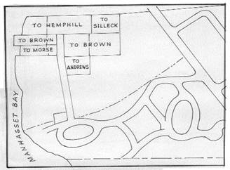
Alice Hemphill was the first
to own land in this location. In February 1922 her father, Charles Dayton
Silleck, bought her the large parcel extending east from the Bay, and in
1934 purchased another contiguous parcel. The Hemphills built a
summerhouse on the property at the point where Shore Road then ended. Two
brick gateposts stood at the entrance of the circular drive in front of
their home. The Hemphills owned this parcel until 1968–69 when they sold
most of their land to a developer who tore down the house. On the plot
they retained overlooking the Bay, they built a lovely home at 89 Shore
Road.
 Howard
M. Morse, a patent attorney in New York City, and his wife Reba purchased
two waterfront parcels in November 1922. Their land included the historic
Plandome Heights home discussed earlier which was built on the Pearsall
property about 1710. To recapitulate, the home was later owned by
Bloodgood Cutter, became an office for the Gallagher sand company, and
then was sold to Henry F. Thompson. Thompson partially rebuilt the house
but never lived there. The Morses modernized the house by adding electricity,
plumbing, and other conveniences. The exterior was painted white with
butter yellow shutters. Photographs of the home reveal the lovely setting
in a lush green open spot on the Bay with natural springs of pure water
nearby. Unfortunately the home burned in a fire in 1965 and another home
was built in its place at 69 Shore Road. Howard
M. Morse, a patent attorney in New York City, and his wife Reba purchased
two waterfront parcels in November 1922. Their land included the historic
Plandome Heights home discussed earlier which was built on the Pearsall
property about 1710. To recapitulate, the home was later owned by
Bloodgood Cutter, became an office for the Gallagher sand company, and
then was sold to Henry F. Thompson. Thompson partially rebuilt the house
but never lived there. The Morses modernized the house by adding electricity,
plumbing, and other conveniences. The exterior was painted white with
butter yellow shutters. Photographs of the home reveal the lovely setting
in a lush green open spot on the Bay with natural springs of pure water
nearby. Unfortunately the home burned in a fire in 1965 and another home
was built in its place at 69 Shore Road.
Howland Brown, a member of the
New York Stock Exchange, purchased both waterfront and upland parcels in
1924 and 1929. On the waterfront parcel he built a dock for his large
yacht. Manhasset Bay was deeper and wider then. His upland property
included a gardener’s cottage (where during the 1920s a man by the name
of John Dietz made his living by hiring out horses) and a large barn
which dated from about 1800. The barn and the Morse farmhouse were
probably all part of the farm owned in the 1800s by the Pearsalls and
then by William Haviland and by Bloodgood Cutter. This structure is now
the oldest surviving building in Plandome Heights. A spicy bit of news is
that during the Prohibition era in the 1920s and early 1930s the barn was
used to store liquor that was smuggled in from the Bay. The “speakeasy,”
which still exists, even had two slot machines. Entrance to the
underground room, which may have originally been a root cellar, was probably
gained through a trap door.
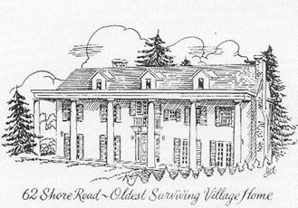 Mr.
Brown eventually converted the barn into a large white-pillared home and
also expanded the cottage. Both still have a commanding view of the Bay
tucked in behind new homes at 62 and 66 Shore Road. Mr.
Brown eventually converted the barn into a large white-pillared home and
also expanded the cottage. Both still have a commanding view of the Bay
tucked in behind new homes at 62 and 66 Shore Road.
Snowden Andrews bought his
parcel in December of 1928 from the Manhasset Hill Realty Company. He
built a home in the southern colonial style with tall white pillars
similar to Brown’s, on the hill where Willow Court is now. The developers
who bought his land in 1966 razed it when they built the Willow Court
homes.
By 1931 the executors of the
Thompson estate who controlled the Manhasset Hill Realty Company were
planning to dispose of their remaining property in Plandome Heights. They
printed a folder, improved the rather steep bluff east of Shore Road by
grading, and set the price from the remaining 20 acres of waterfront and
upland property at $350,000, plus $25,000 for Thompson’s son’s home on
the corner of Bay Driveway and Shore Road. It seems that the property was
not sold because it remained in the hands of the Manhasset Hill Realty
Company during the 1930s and eventually was partially developed by them.
As early as 1931, however,
when the Village Planning Board heard that the property was on the
market, it was poised for its coming responsibility. In 1937 the
Manhasset Hill Realty Company submitted a proposed subdivision map of the
area to the Planning Board. The plot plan showed a rather congested
number of homes on three streets: Wayside Run, Littleworthe Lane and Dedham
Byway. The plan was not approved.
By 1939 the Planning Board was
chaired by Walter Burr and included Ada Carleton, R. Snowden Andrews,
Leonard Wickenden, and Edward Breen. They began to meet almost weekly.
They faced an awesome responsibility in guiding the village’s development
and their story is recounted below.
On January 12, 1939 the Board
rejected another proposed development submitted by the Manhasset Hill
Realty Company. This plan included over 92 plots and did not comply with
the Village Zoning Ordinance requiring a minimum plot size of 9000 square
feet, and concrete roads and sidewalks. On January 18 Mr. N. Boyce
Jenkins of Sands Point, the builder, submitted another plot plan, which
was also rejected because it didn’t even present a true outline of the
property.
Then John Isaacs, the mayor,
had a plot plan prepared by the Manhasset Civil Engineers and submitted
it to the Planning Board on January 24. This plan called for two parallel
curved streets leading down to Shore Road, with concrete pavements,
curbs, and sidewalks. It was approved.
However, not for long. On
February 11, the Village Planning Board denied building permits to the
Manhasset Hill Realty Company for the first 13 lots. On February 14 some
board members resigned, and John Isaacs and W. Arthur Lee were appointed
in their place. A resolution was passed not to file the January 24 plan.
Another resolution was passed, strictly enumerating village building
requirements for streets, curbs, sidewalks, and storm basins.
On February 28 Mr. Jenkins
submitted a tentative plot plan, just for the Cove Drive area, and agreed
to conform with village requirements for streets, lights, and drainage.
On March 16, he returned with the final map entitled Manhasset Cove. The
Planning Board passed a resolution that since the plan generally met the
Board’s requirements, a public hearing would be held on March 27.
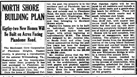
At the hearing the information
was released that the property would be developed by the Jan Rock
Corporation, whose main incorporators were Harold E. Rounds of Kings
Point and N. Boyce Jenkins of Sands Point. The development would be
called Manhasset Cove; colonial homes would be built on lots of at least
9000 square feet in four sections. Immediately after the hearing the
Planning Board met and approved the plan. The next month in April 1939,
the Jan Rock Corporation was changed to the Manhasset Cove Corporation,
and the building of the first eleven homes on Cove Drive began. The
article below, detailing the development, appeared in a New York
newspaper.
 As
it turned out, the Manhasset Cove Corporation never realized its rather
grandiose plans. Either because of financial conditions or because of
World War II, it was able to build only the first eleven homes on Cove
Drive. During the years 1940–43, the Manufacturers Trust Company held a
lien on the Corporation’s property, and the village taxes were unpaid. As
it turned out, the Manhasset Cove Corporation never realized its rather
grandiose plans. Either because of financial conditions or because of
World War II, it was able to build only the first eleven homes on Cove
Drive. During the years 1940–43, the Manufacturers Trust Company held a
lien on the Corporation’s property, and the village taxes were unpaid.
As a result, in March of 1944
a land auction was held at Mayor Isaacs’ home. Patrick and Cecilia Callan
succeeded in buying all of the undeveloped portion of Manhasset Cove.
However, the layout of the area had to be replanned since in February
1940, R. Snowden Andrews had bought two strips of land abutting his
property, which cut into a proposed street on the 1939 plot plan. So
during 1944, 1945, and 1946 the area was surveyed again and replanned.
Instead of two parallel streets running down to Shore Road, the present
street layout was designed, with The Neck and The Waterway joining Cove
Drive.
After World War II, when
building materials were plentiful again, Callan Builders Inc. built the
brick homes on The Waterway, The Neck, and lower Cove Drive. Some of the
interior designs were similar to the original Manhasset Cove homes on
upper Cove Drive.
Then in 1948 the Planning
Board approved the layout of another pocket of homes near Shore Road. The
street was at first called Andrews Place in honor of R. Snowden Andrews
but then, in keeping with the unofficial village policy of naming a
street after its geographical area, was named The Beachway. A narrow
strip of land at the end of the Beachway was set aside to provide public
access to the beach. Callan Builders built these 10 homes on The Beachway
and Shore Road during 1948.
Edna Cooper of 2 The Beachway remembers. . .
the wonderful Fourth of July
celebrations the Beachway residents used to enjoy. They closed off the
top of the street with sawhorses and had a block party on the circle.
Bridge tables were set up, everyone brought food, and there was music,
singing and fireworks for the children.
The Beachway residents were a
cohesive group. They even formed their own organization called “The
Beachway Folk” and had a letterhead printed. John Mezey of 15 The
Beachway was President; “Hap” Lyons of 9 The Beachway was Vice-President;
and Mr. and Mrs. Frank Pickles were Treasurer and Secretary,
respectively. Another resident was Cecilia Callan who moved to 23 The
Beachway from Munsey Park after her husband, the builder of Manhasset
Cove, died in 1949. In 1953 when the roadwork and drainage work on the street
was completed, the Beachway residents petitioned the Planning Board to be
recognized as part of the Incorporated Village of Plandome Heights. They
joined the village that year.
The
Development and Annexation of Chester Hill
 In
1949, the year of the 20th Anniversary of the incorporation of the
village of Plandome Heights, the village was greatly enlarged by the
annexation of an area called Chester Hill. In
1949, the year of the 20th Anniversary of the incorporation of the
village of Plandome Heights, the village was greatly enlarged by the
annexation of an area called Chester Hill.
No one seems to know for sure
why this area, leading up to Flower Hill, was called Chester Hill. It may
have been named after a Manhasset landowner named John Chester. Since the
early 1900s the land had been part of the Alice Grace D’Oench estate. It
was a lovely grassy plain with a brook and pond on the eastern end. In
March of 1932, when Mrs. D’Oench died, the property went in trust to
Joseph T. Grace, William R. Grace, and Adolf Garni. Then in 1937 these
trustees sold the land to a development company called Chester Hill
Manhasset Inc. The area, almost 32 acres, was surveyed, and the plot plans
were approved by the Town of North Hempstead’s Planning Board.
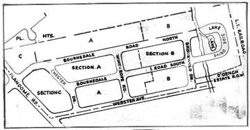
It was divided into three
vertical sections. Sections A and B were developed in 1938-40; as it
turned out Section C was not developed until the 1950s. The meandering
brook at the eastern end of the property was relocated within a 12-foot
reserved strip. Another strip of land, here labeled the D’Oench Estate
Chester
Hill Development Plan
Right of Way, was reserved for
a road going over the railroad tracks to Flower Hill. Originally a road
called Lake Side Drive was planned around the lake, but this never
materialized. The new streets were called Bournedale Road North,
Bournedale Road South, Chester Drive, Winthrope Road, and Brookwold
Drive. Chester Drive undoubtedly was named after Chester Hill. The
Bournedales were probably named after the beautiful words “bourn(e)” and
“dale” meaning “a stream” in “a vale.” Likewise, Brookwold Drive seems to
have been named after its geographic area: “brookwold” means “a brook” on
“an unwooded plain.” Webster Drive had already been built in the late
1920s as part of a section called Manhasset Gardens, which comprised the
streets of Lindbergh, Gaynor, Vanderbilt, and Webster. These streets were
named after famous people who either visited or had relatives living
here, Webster being named after Daniel Webster.
Oleg Gaydebouroff of 164 Plandome Court remembers. . .
that growing up in Plandome
Heights in the 1930s was something special. He used to play Indian by
making bows and arrows with real arrowheads that he found on the area
that became Cove Drive. He found horseshoes buried on his own property.
He and his friends would also play on D’Oench’s farm, teasing the bulls
and cows, catching sunfish and pollywogs in the pond, and playing “donkey
baseball” on the field by the railroad track. This game consisted of
hitting the ball, then jumping on a donkey and trying to get it to run
the bases before being tagged out!
In 1949 most of Chester Hill,
except for Section C, had been developed. In that year as a result of a
Manhasset Civic Liaison Committee’s report, all of the unincorporated
areas adjoining the Plandome Road business district began to discuss
incorporation. This included Norgate, Shorehaven, and Chester Hill. At
first they discussed incorporating as separate villages. On May 10, 1949,
at a meeting held at Manhasset High School, they discussed incorporating
as one village. After the meeting Plandome Heights Mayor W. Arthur Lee
discussed annexing Chester Hill to Plandome Heights.
On May 17 nearly 150 people
attended a mass meeting of Chester Hill residents to discuss the proposed
annexation. At the meeting’s end they unanimously approved a resolution
to petition the Town Board to join Plandome Heights. At a meeting the
same night Shorehaven residents also voted unanimously to petition to
join Plandome Heights. However, the latter annexation movement did not
proceed because the village law was interpreted to exclude the annexation
of another unincorporated area which was not contiguous to the village.
Over 90% of the eligible
voters of Chester Hill who represented over 90% of the assessed property
signed the petition for annexation. On July 26 a majority of the Town
Board consented to the annexation. Now it was up to the residents of
Plandome Heights.
The Plandome Heights Civic
Association, whose president was W.E. Himsworth, issued a 2-page letter
on the question. Reasons given in support of annexation were:
- It would improve our chances of zoning control on
the vacant property on the east side of Plandome Road just north of
Webster Avenue.
- We would be able to control parking on Plandome
Road at this point.
- It would strengthen our position as a village by
increasing its size and spreading our community of interest.
In fact, it was pointed out,
the annexation of Chester Hill would increase both the population and the
assessed value of the village by almost exactly 50%. Chester Hill had a
population of 311; Plandome Heights had 628. Chester Hill had 92 homes
with a total property assessment of $902,000; Plandome Heights had 157
homes with $1,804,000 worth of property.
The Plandome Heights
permissive referendum to annex Chester Hill was held on September 7, 1949
at Mayor Lee’s house at 101 Summit Drive. It passed and by September 14,
when all the necessary papers had been filed, Chester Hill officially
became part of the Incorporated Village of Plandome Heights.
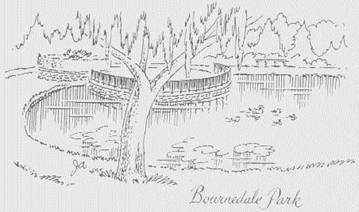 During
the 1950s the rest of Chester Hill was developed. The western end,
Section C on the plot plan, was an empty lot fronting on Plandome Road
and for many years had been a source of irritation to neighbors because
some people used it for parking or for dumping rubbish and grass
cuttings. So in 1952 plans were drawn and approved for a subdivision of
10 homes called Manhasset Grove, which would be built by the P.C.R.
Development Corporation. Also that year, Reverend Donald Weymouth, pastor
of the Manhasset Baptist Church, made plans to purchase the southern part
of the lot. His church had formerly held services at the Onderdonk House
in Manhasset but now needed a larger building. Rev. Weymouth felt that
his church would also provide a good buffer between the Plandome Road
stores and the residential village of Plandome Heights. In 1953–54 the
church launched a building fund campaign, and soon after the new church
was built. During
the 1950s the rest of Chester Hill was developed. The western end,
Section C on the plot plan, was an empty lot fronting on Plandome Road
and for many years had been a source of irritation to neighbors because
some people used it for parking or for dumping rubbish and grass
cuttings. So in 1952 plans were drawn and approved for a subdivision of
10 homes called Manhasset Grove, which would be built by the P.C.R.
Development Corporation. Also that year, Reverend Donald Weymouth, pastor
of the Manhasset Baptist Church, made plans to purchase the southern part
of the lot. His church had formerly held services at the Onderdonk House
in Manhasset but now needed a larger building. Rev. Weymouth felt that
his church would also provide a good buffer between the Plandome Road
stores and the residential village of Plandome Heights. In 1953–54 the
church launched a building fund campaign, and soon after the new church
was built.
The last remaining section of
Chester Hill to be developed was the extreme eastern end. Lake Side Drive
and the homes around it were not built as originally planned. Instead, in
the late 1950s Nassau County acquired the property for a water recharge
basin and then, after protestations by Chester Hill residents, built a
lovely park around the pond to cover up the necessary pipes.
Land
Development 1950-2001
In 1954 Homestead Properties
purchased the Bayview Circle area and proceeded to build and sell homes
there in 1955–56. In April of 1956 the company sold the remaining land to
Otruba Homes, Inc.
In the 1960s the large parcels
fronting on Shore Road were developed in two sections. First Snowden
Andrews sold his 2-acre plot in 1966 to the Lyneti Construction Company
of Albertson. His lovely white-pillared home on the hill was razed and
the Tivel Construction Corporation built the large Willow Court homes.
The name of this development was Heritage at Plandome Heights.
Then in 1968 the Paddons and
Hemphills sold their plots, which totaled 5 acres, to another developer
who sold the land to the Plandome Heights Development Corporation, which
built the large Country Estates homes on upper Shore Road. In the process
the Hemphill’s summer home was razed, and a new one was built overlooking
the Bay at 89 Shore Road. The Paddon’s home at 62 Shore Road, formerly
owned by Howland Brown, was preserved, as was the home next to it at 66
Shore Road.
It could be added that in 1969
the tiny triangle of land on Plandome Road at the northern entrance of
Plandome Court was also “developed.” In June of that year Plandome
Heights celebrated its 40th year of incorporation by dedicating a
flagpole on Flag Day to Jack Isaacs. A large rock and plaque at the base
of the flagpole mark the occasion. At the dedication ceremonies Jay
Boyle, President of the Civic Association, made the presentation of the
flag; Ray Kremer, Mayor of Plandome Heights, dedicated the flag pole; and
Robert Meade, Supervisor of the Town of North Hempstead, presented a
proclamation. In the proclamation Jack Isaacs was recognized for having
served the community well for 40 years. For fifteen years he had served
as Mayor of Plandome Heights; for twelve years he had served as Manhasset
Park District Commissioner; and for seventeen years he had served as
member of the Town of North Hempstead’s Board of Zoning and Appeals. In
addition to his community involvement, Isaacs was also cited for his
personal integrity and high principles.
By the 1970s there were no
large areas of undeveloped land remaining in Plandome Heights, just a few
plots here and there. During the 1970s new homes were built on
practically all of these individual plots. These included four new homes
on Grandview Circle, one at the top of Bay Driveway, one on Bayview
Circle, two on Plandome Court, one on Bournedale Road North, and one on
upper Shore Road.
In 1979 the Village Planning
Board held hearings on the development of a 3-acre parcel known as the
Otruba property, which lies at the foot of Bayview Circle overlooking
Manhasset Bay. The Otruba Builders’ plan called for building three homes
on a private road on this parcel and for deeding the remaining two acres
of waterfront property to the village for a park. The Planning Board granted
final approval on May 19, 1979. The three houses, located at numbers 2,
4, and 6 Waterside Lane, were built in the mid 1980s. The village
acquired title to the two waterfront acres by deed dated June 20, 1980.
 It
should be noted that in 1949 the village was considering this same parcel
for a pool and tennis club and even circulated a flyer and postal card on
the matter. Plans called for building a swimming and wading pool, a
clubhouse which could double as a village hall, plus later if desired, four
tennis courts, a children’s playground, and a barbecue pit. The Club
would have been financed, owned and operated by its members and run as a
nonprofit corporation. Other plans for a club or park were also proposed
to village residents in the 1950s and in the 1960s by the Plandome
Heights Civic Association, but they never materialized. It
should be noted that in 1949 the village was considering this same parcel
for a pool and tennis club and even circulated a flyer and postal card on
the matter. Plans called for building a swimming and wading pool, a
clubhouse which could double as a village hall, plus later if desired, four
tennis courts, a children’s playground, and a barbecue pit. The Club
would have been financed, owned and operated by its members and run as a
nonprofit corporation. Other plans for a club or park were also proposed
to village residents in the 1950s and in the 1960s by the Plandome
Heights Civic Association, but they never materialized.
Building activities for new
structures in the 1990s numbered only three. In 1994 two houses were
built: one on Bay Driveway and another on Grandview Circle. The other
major project in the village concerned the Manhasset Baptist Church,
which is located on the corner of Plandome Road and Webster Avenue. The
Baptist Church, a Manhasset fixture since 1943, has experienced
remarkable growth during the last two decades. As a result, in 1992,
church leaders decided to expanded its facilities.
Other than improvements to
existing housing stock, there has been no further development in the
village. However, in order to protect the character and beauty of
Plandome Heights and still allow for improvement, the Mayor and the Board
of Trustees undertook one of the most important legislative actions in
the year 2000. The enactment of the Architectural Review Board (ARB) was
finalized after many months of thoughtful deliberation. Its stated
purpose is “... to preserve and promote the character and appearance, and
conserve the property values of the village by providing procedures for
an architectural review of buildings and structures henceforth erected,
reconstructed or altered in the village, and thereby to encourage good
qualities of exterior building, design, and good appearances and to
relate such design and appearances to existing buildings and structures.
… ”
The
Village Celebrates Its Anniversaries
Over the years, the Village of
Plandome Heights has marked its incorporation with special celebrations.
For its 40th Anniversary, the village dedicated a flagpole at Plandome
Court North and Plandome Road on June 14, 1969 in honor of Jack Isaacs,
Plandome Heights Mayor from 1931 to 1945.
The 50th Anniversary
celebration was a joint effort of Plandome Heights officials and the
Plandome Heights Women’s Club. Carolee Brown, Village Trustee, and
co-chairpersons Dollie Boyle and Ursula Kenny organized a dinner-dance
for June 2, 1979 at North Hempstead Country Club. In conjunction with the
celebration, the first edition of A History of the Incorporated Village
of Plandome Heights was published. Village Historian Arlene Hinkemeyer,
who served from 1978 until 1996, researched and wrote the history.
On Saturday, June 12, 1999,
village officials, residents and honored guests Thomas Gulotta, Nassau
County Executive, and Town of North Hempstead Supervisor May Newburger
gathered to celebrate the 70th Anniversary of the incorporation of
Plandome Heights. A dinner-dance took place at the Port Washington Yacht
Club with music by Ron James. The Anniversary Committee was chaired by
Trustee Marion Endrizzi and co-chaired by Susan Brown and Patricia Burch.
A
Profile of Plandome Heights Today
The Village of Plandome
Heights encompasses an area of approximately 220 acres with 3.3 miles of
village roads and has an ideal location. The village is a secluded,
quiet, and entirely residential area. Yet it is conveniently situated
within walking distance of Plandome Road shops, both public and parochial
schools, a variety of houses of worship, the Long Island Railroad train
station, and also Manhasset Bay.
Though previously
unrecognized, its recorded history is long and distinguished, dating from
1686. It includes such prominent local figures as Nathaniel Pearsall,
William Haviland, Bloodgood Cutter, Benjamin Duke, Henry F. Thompson, and
Alice Grace D’Oench.
There are 326 homes in the
village. They are well constructed, and are an interesting blend of old
and new architectural styles. The population of Plandome Heights has
grown steadily through the decades, but it has since stabilized.
The residents of Plandome
Heights include members of many nationalities and religions, a good representation
of both major political parties, and a good mixture of both older or
retired families, and younger families with school-age children. The
people of Plandome Heights are friendly and have come to know each other
well, due to organizations like the Plandome Heights Civic Association
and the Plandome Heights Women’s Club. Many village members are also
active in the greater Manhasset community.
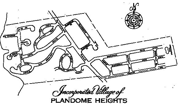
Village
Government
Plandome Heights, located
between the territorial limits of Manhasset proper and the Incorporated
Village of Plandome, is one of the 31 incorporated villages in the Town
of North Hempstead.
The Village Government
includes the following officials:
Elected
Officials:
- Mayor—elected to office for a two year term. The
Mayor presides at the meetings of Board of Trustees, serves as
budget officer, and is responsible for the execution of contracts in
the name of the village. The Mayor appoints all members to the
various village boards, non-elected officials, and employees. These
appointments are subject to the approval of the Board of Trustees.
The Mayor also provides for the enforcement of all laws, rules, and
regulations.
- Board of Trustees—six officials elected to office
for two-year staggered terms. The Mayor appoints one trustee to be
Deputy Mayor. The function of this official is to assist the Mayor
and act for the Mayor in his/her absence.
- Village Justice—elected to office for a four-year
term. The function of this official is to administer and interpret
the village laws and to preside over the Village Court.
The Mayor and Board of
Trustees serve the village in both executive and legislative
capacities. All village meetings are subject to Open Meetings Law
and open to the public. "Executive Sessions" may be held
by the Board of Trustees only, to discuss specific topics related to
litigation, real estate transactions and personnel matters, and are
closed to the public. Any actions resulting from an Executive
Session, however, is public and reflected in the Minutes.
Appointed
Officials
The Mayor appoints candidates
for the following positions subject to the approval of the Board of
Trustees:
- Architectural Review Board—five members and one
alternate member—provides oversight on all architectural alterations
or construction
- Planning Board—five members—approves map
subdivisions
- Technology Advisory Board—three members—advises
Mayor on all technology equipment and IT issues
- Zoning and Appeals Board —five members—hears and
rules on appeals for variances from the village building and zoning
codes
- Village Attorney—provides legal advice as needed
by any village board
- Acting Village Justice—performs the duties of the
Village Justice in his/her absence
- Historian—records the history of the village and
represents the village in the New York State Historical Society
- Treasurer—chief fiscal officer, collects taxes,
and records all receipts and expenditures of village funds
- Clerk—maintains all records pertaining to the
village; records the minutes of all board meetings; issues building
permits, certificates of occupancy; and is responsible for all
correspondence and reports of the various boards. This official also
serves as clerk of the Planning and Zoning and Appeals Boards
- Deputy Clerk—assists the Village Clerk
- Court Clerk—assists the Village Justice
- Building Inspector— approves all building plans
and inspects all construction within the village to ensure that it
adheres to the village building code
- Storm Water Management Officer— ensures
compliance to New York State MS4 requirements; monitors all
water-related problems with VPH that may negatively affect Manhasset
Bay
- Village Engineer—provides engineering advice as
needed by the village
Voter
Information
Village elections are held the
third Tuesday in March, except in 2009 when elections will be held on
Wednesday March 18th.
The qualifications for voting
are: a voter must have been a citizen of the United States for ninety
days; must be eighteen years of age; must have lived in the state for one
year, in the county for the past four months, and in the village for the
past thirty days.
Services
rendered to Plandome Heights residents by the village via contract
- maintenance of village roads and drainage system
- snow removal
- lighting of village roads
- refuse collection
Services
rendered to Plandome Heights residents by wider districts:
- police protection—Nassau County Police Department
- fire protection—Manhasset-Lakeville Fire
Department
- water—Manhasset-Lakeville Water District
- public education—Manhasset Union Free School
District
- library—Manhasset Public Library System and the
Nassau Library System
- parks and parking lots—by the Manhasset, the Town
of North Hempstead, and the Nassau County Park Districts
The
Plandome Heights Civic Association
Complete records of the history of the Plandome Heights Civic Association do not exist. What is known is that the organization was incorporated in New York State on July 10, 1943 by seven Plandome Heights residents: Frank Rhatigan, Hugh Maher, and Charles E. Nylund of Cove Drive; E.B. Breen and R.M. Giles of Bay Driveway; and Winston E. Himsworth and E.B. Lipsett of Plandome Court. Frank Rhatigan was the Civic Association’s first President. It is thought that the reason for the Civic Association’s origin at this time was to promote the beach at the end of Bay Driveway and to unify the village during the World War II years.
During the 1940s and the 1950s the Association was very active and promoted the social cohesiveness of the village by arranging numerous beach cookouts and dinner dances. However, during the subsequent decades the group faded in and out of existence several times.
After a period of inactivity, the Civic Association was reactivated in 2010 by a group of former Village Officials and concerned residents including Marion Endrizzi, Paula Abate, Mike and Jayne Knox, Roxanne Fitzig and Dan Cataldo. The current goals of the Civic Association are to:
-
Promote the welfare of our members through civic activities
-
Advocate transparent and accountable government that is responsive to our residents
-
Encourage the wise and efficient use of taxpayer dollars
-
Work actively with The Council of Greater Manhasset Civic Associations
-
Provide pertinent information and encourage public participation
-
Support reforms necessary to achieve the purposed stated.
The
Mayors of Plandome Heights
John S. Olney, 1929-1931
John F. Isaacs, 1931-1945
Gottfried Steigmann, 1945-1949
W. Arthur Lee, 1949-1953
Charles S. Vaccaro, 1953-1960
Richard Wallover, 1960-1962
Thomas V. Sheehy, 1962-1963
Burton R. Buck, 1963-1965
Edward F. Pardee, 1965-1968
Ray H. Kremer, 1968-1972
H. William Galland, 1972-1974
Arthur J. McGee, 1974-1980
Thomas N. Clancy, 1980-1986
Paula Abate, 1986-1988
John F. Keitz, 1988-1998
Paula Abate, 1998-2002
George Ferman, 2002-2003
Sandi Gabriele, 2004-2005
Marion Endrizzi, 2005-2006
Gene Woo, 2006-2008
Diana Merenda, 2008-2012
Kenneth C. Riscica, 2012-present
At the 70th Anniversary of the
incorporation of Plandome Heights on June 12, 1999, Nassau County
Executive Thomas Gulotta presented the village with a Nassau County Flag.
From left to right: Bart Giusto, Trustee; Alan Zaremba, Deputy Mayor;
Thomas Gulotta, Nassau County Executive; Paula Abate, Mayor; George
Ferman, Trustee; Marion Endrizzi, Trustee; James Hills, Trustee.
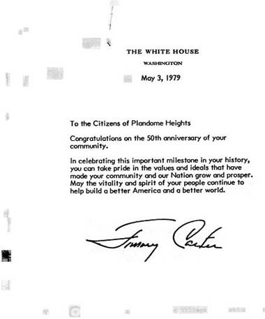 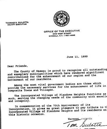
Acknowledgments
Arlene
Hinkemeyer extends special thanks to the
following people who provided significant and much appreciated assistance
during the various stages of researching this history: Leila Mattson,
Arthur J. McGee, William Miller, Reba Morse, Esther Morse, Frank J.
Pistone, Gottfried and Agnes Steigmann.
Thanks are also extended to
the following organizations and people who enthusiastically and
generously contributed assistance, time and information for this booklet:
John and Mary Allen, American Title Insurance Company, Henry Anderson,
Dr. A. Avata, June Bartlett, Jay and Betty Boyle, John and Dollie Boyle,
Lyman and Carolee Brown, Burton Buck, Bryant Library Staff, John and Pat
Bruderman, Tom Conway, Harry and Edna Cooper, Bill and Barbara Curran,
Ann D’Aguanno, Monty Davis, Henry and Sally DeMeli, Beverly Draves, Joan
Eigo, First Federal Savings and Loan Association of Port Washington,
Allan and Judy Flynn, Bill and Rachel Galland, Oleg Gaydebouroff, Ken
Gorman, Donald Gray, Great Neck Public Library, Bernie Gutmann, Tom
Hemphill, Ralph Keesing, Ursula Kenny, Bernice Lee, Thomas LeViness, Dr.
Myron Luke, Emma Lou Lyons, Manhasset Public Library Staff, Mary Mezey,
Frank Modica,
M. Douglas Neier, Karl
Prewein, Florence Rhatigan, Dwight and Virginia Rollins, James Schwabe,
Norma Sobeck, Marcelle Stratton, Town of North Hempstead Historical
Society, Charles and Mildred Vaccaro, Charles Vaughn, Ruth Walker, Waldo
and Loretta White, and Charles Young.
Eleanor M.
Imperato wishes to thank the following
people for their gracious assistance in updating this history: Paula
Abate, Fran Bourguet, Eileen Brennan and the staff of the Manhasset
Press, Barbara Curran, Camille Dee, Marion Endrizzi, George and Aida
Ferman, Bart Giusto, Dr. Pascal James Imperato, Alison M. Imperato, Gavin
H. Imperato, Austin C. Imperato, Maggie Kennedy, Brigid McCarthy,
Manhasset Public Library, Esther Morse, Felipe Pardo, and Florine Polner.
Bibliography
of Main Stories
Books and
Periodicals
Cow Neck Historical Society.
Sketchbook of Historic Homes. Port Washington: 1963.
Cutter, Bloodgood H. The Long
Island Farmer’s Poems. New York: N. Tibbals & Sons, 1886.
Hicks, Benjamin D., ed.
Records of the Towns of North and South Hempstead. Vol. I–VIII, Jamaica,
New York: 1896.
History of Little Neck. Wm.
James & Co., 1952.
Johnson, Allen, and Malone,
Dumas, eds. Dictionary of American Biography. New York: Charles
Scribner’s Sons, 1930, 1931.
Vol. III (pp. 496-98), Vol. IV (p. 463).
League of Women Voters of Port
Washington-Manhasset. This is Manhasset. 1974.
Manhasset Mail. Manhasset
Press.McDermott, Charles J. Mark Twain’s L.I. Poet “Lariat,” Long Island
Forum. December, 1958, p. 229+.
National Cyclopedia of
American Biography. New York: James T. White & Co., 1939, 1950, 1960.
Vol. XXI (pp. 11–12), Vol.
XXVII (p. 109), Vol. XXXVI (p. 303), Current Vol. I (p. 66).
The New York Times.
Nowacek, Mary L. The Heritage
of Manhasset. Manhasset: Octava Ventures Group, 1975.
O’Shea, John E. History of the
Town of North Hempstead. 1968.
Pearsall, Clarence E., ed.
History and Genealogy of the Pearsall Family in England and America,
3 vols. San Francisco: H.S.
Crocker Co., 1928.
Pelletreau, William S. A
History of Long Island, Vol. III. New York: Lewis Publishing Co., 1903.
Sutherland, Claire, compiler.
The Plandome Story, 1911–1965. 1965.
Thompson, Benjamin F. History
of Long Island. New York: Gould, Banks & Co., 1843.
Files and
records
Birth, death, historical, and genealogical
records of Zion Episcopal Church, Douglaston, New York.
Historical files of the
Village of Plandome Heights, Village Clerk’s office.
Local history files of the
Manhasset, Great Neck, Port Washington, and Roslyn Public Libraries, and
the Eisenhower Park Museum.
Nineteenth and twentieth
century deeds to Plandome Heights lands, Nassau County Clerk’s office,
Mineola.
Historical
Maps
William M. Stewart, Map of the
Town of North Hempstead, 1797.
J. Calvin Smith, Map of Long
Island, New York, 1852.
H.F. Walling maps, 1859, 1863.
Beers, Comstock & Cline.
Atlas of Long Island, New York, 1873.
Map of Nassau County, 1886.
Hyde & Co., Map of Long
Island, 1896.
E. Belcher Hyde. Atlas of
Nassau County, Brooklyn, 1906.
E. Belcher Hyde, Atlas of
Nassau County, New York, 1914.
E. Belcher Hyde, Inc., Map of
Nassau County, 1923.
Dolph & Stewart, Map of
Nassau County, N.Y., 1932.
Interviews
See listings on
Acknowledgments page. |